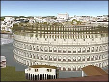
 Google Earth now includes a 3D reconstruction of ancient Rome. It's the first historical city to be added to Google Earth, and contains more than 6,700 buildings.
To create the virtual reality city, Google Earth teamed up with researchers from the Rome Reborn project at the University of Virginia. They have spent years building a digital model of Rome as it appeared in 320 AD. Their starting point was a 1:250 plaster model of the city called Plastico di Roma Antica, which is housed in Rome's Museum of Roman Civilisation.
You can see a tutorial on how to access Google's Rome here. To be honest I found it awkward to use, and not as impressive as it looks in this video. I really love this clip from the Rome Reborn project though, which flies you through the city's eerily empty streets. In 320 AD, Rome was home to a million people, and the capital of the western world. It's just so huge, and so incredibly grand. Of course the poverty that most of the city's inhabitants would have lived in doesn't show up well here. But leaving that to one side, you could almost believe that this was a vision of 1700 years in the future, not 1700 years in the past...